Increasing accessibility with new mobility maps
Navigating footpaths in Maryborough and Hervey Bay is set to become easier for pedestrians with disabilities, parents with prams, and elderly citizens, thanks to the introduction of new mobility maps.
Fraser Coast Regional Council has engaged with Briometrix to undertake a comprehensive “mapping” process. This project involves a survey team, including trained Wheelchair Users (pilots), utilising innovative technology to gather data on footpath conditions, accessibility to public transport, parking, and amenities.
Fraser Coast Mayor George Seymour said these new mobility maps will help our most vulnerable to find the best footpath, shared pathway, or trail, giving those with limited mobility the confidence to take a journey that they might not previously have done.
“The project surveys approximately 95km of footpaths and assesses access to more than 500 locations including bus stops, toilets, parking bays, clubs, tourist attractions, retail centres, food outlets, accommodation providers and entrances to council facilities,” said Cr Seymour.
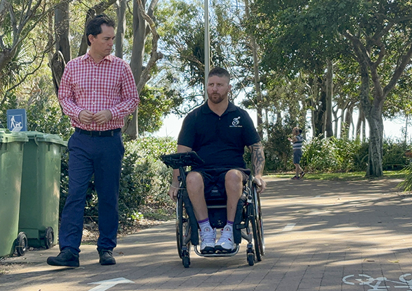
“Paul Crawford, a local resident of Fraser Coast who uses a wheelchair, has undertaken the mapping of paths in Hervey Bay and Maryborough, aiming to help improve accessibility.
“In Hervey Bay, mapping included areas such as the Boat Harbour Marina, coastal walking paths along the Esplanade to Point Vernon, paths to the shopping precinct on Main Street and further along as far as Eli Waters Shopping Centre.
“In Maryborough, paths were assessed from the Railway Station in the town centre to Richmond Street, then extending Northeast along Lennox Street as far as Woodstock Street then out as far as Aldridge High School.
“This key information is then used to create an online “Mobility Map” that will soon be accessible to the community, helping people to plan safe outings using our pathways.
“This project has become a nationally recognised award-winning project on the Sunshine Coast, and we look forward to the same success on the Fraser Coast.”
CEO of Briometrix, Natalie Verdon said "Working with the Fraser Coast Council has been a rewarding experience. Their progressive approach to data-driven solutions will ensure this project's benefits extend far beyond infrastructure, supporting urban and transport planning, accessible tourism and economic development for the entire region."
New mobility maps now available: Mobility Corridor Project